Luke Dittrich: Walking the Border
There is only one way to understand the 1,933-mile line that divides our country from Mexico. Start at the beach and walk east until you hit the Gulf.
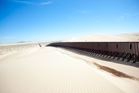 IMPERIAL SAND DUNES Before 2008, the Imperial Sand Dunes were a hotbed of drug-trafficking activity, as smugglers would simply blend in with the usual crowd of helmeted ATV and dune-buggy drivers, hauling their loads across with relative ease. Now there’s a fifteen-foot-high and roughly ten-mile-long “floating fence” that rides atop the dunes and has dramatically slowed crossing attempts.
The fence starts about eighty feet out into the Pacific. It’s made of metal pylons and looks like a procession of old telephone poles, each jutting about twenty feet above the waves. The pylons are spaced tightly together, and there’s a sign warning of additional barriers below the waterline. Once the fence hits dry land, it marches east across the beach, and then, on a little hill that begins where the beach ends, it changes. It becomes, in fact, two fences, a double barrier. Compared with the single-ply barrier on the beach and in the water, these two fences — sturdy square beams supporting tight rows of whitewashed steel spindles — look much more modern and formidable, like prison fences. One of the two fences picks up right where the beach fence leaves off and continues east along the actual borderline, while the other follows a parallel line a few dozen feet to the north of it.
The buffer zone between the two fences is reserved exclusively for the use of the U. S. Border Patrol, with one exception: At the top of the hill, there is a little door in the northern fence, and a sign informs that twice a week, Saturdays and Sundays from 10:00 A.M. until 2:00 P.M., U. S. citizens are allowed to enter. Then, if there happen to be Mexicans on the other side of the second, southern fence, the Americans are allowed to look at them and talk with them, though reaching through the fence or attempting “physical contact with individuals in Mexico” is prohibited. A portion of the American side of the visiting area has been paved with cement, in the shape of a semicircle, and there is an identical semicircle on the Mexican side of the fence.
The official name of this place is the “Friendship Circle.”
A big marble obelisk stands in the center of the circle. There is a break in the southern fence to accommodate the obelisk, and some additional fencing around the break to keep anyone from trying to squeeze through.
In 1851, some men from something called the International Boundary Commission placed the obelisk here. Back then, the Mexican-American War had just ended, and Mexico had agreed to surrender more than half its territory to the United States, including the places now called California, Arizona, New Mexico, and Texas. The job of the International Boundary Commission was to come up with a map of the revised frontier between the two countries. They started here, on this beachfront hill, and installed the obelisk as their first survey marker.
Then they walked east, into the borderlands…
http://www.esquire.com/features/mexican-border-0511-5#ixzz1KmudQsFS


