Satellites Spot Fields Idled by Drought : Image of the Day
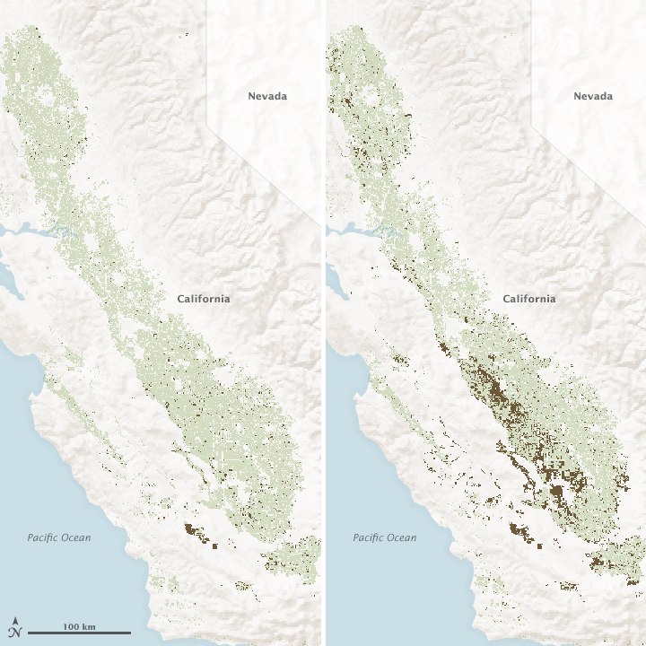 Change in Agricultural Lands 2011 vs 2014
2014 was the driest calendar year on record in California, and with dwindling water levels in reservoirs, the effects started to spread through the state’s farms and North America’s produce aisles. California is the leading producer of agricultural products in the United States, based on cash receipts for fruits, vegetables, nuts, dairy and meat products. But as a result of the drought, many growers received less than a tenth of their full water allotment from state surface water supplies. The deficit had to be made up by pumping trillions of gallons of groundwater for irrigation or by letting fields go fallow.
The statewide maps above and the closeup map below are based on data from the Landsat series of satellites (L5, L7, and L8) and from the MODIS instruments on NASA’s Terra and Aqua satellites. They show changes in crop cultivation and idle agricultural lands in California in August 2011 and August 2014. Brown pixels depict farms and orchards that have been left fallow, or “idled,” since January 1 in each year. Green pixels show plots where at least one crop was grown during the calendar year.
Note how little acreage was idle in the Central Valley in 2011, the most recent year with average or above average precipitation across the state. The most pronounced changes from 2011 to 2014 appear along the west side of the San Joaquin Valley. Also interesting are the idle fields at the north end of the Sacramento Valley, some of which are associated with water transfers from rice growers.
More: Satellites Spot Fields Idled by Drought : Image of the Day


