Hurricane Alex Forms
This is not a good way to start off the new year.
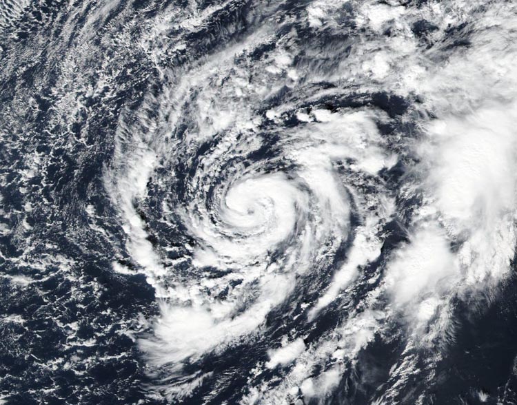 Small Hurricane Alex, by the Azores
Remarkably, Alex has undergone the transformation into a hurricane.
A distinct eye is present, embedded within a fairly symmetric mass
of deep convection. Water vapor imagery shows that the upper-level
trough is now west of the cyclone, with divergent flow over the
center - indicative of a tropical transition. It is very unusual to
have a hurricane over waters that are near 20 deg C, but the
upper-tropospheric temperatures are estimated to be around -60 deg
C, which is significantly colder than the tropical mean. The
resulting instability is likely the main factor contributing to the
tropical transition and intensification of Alex. With these
changes, the government of the Azores has issued warnings for most
of the Azores islands.The initial intensity is set to 75 kt in accordance with the
analyzed Dvorak T-number of 4.5. Only slight additional
intensification seems possible since the system will be passing
over even colder waters during the next day or two. In 36 hours,
the global models suggest that the cyclone will become
extratropical as it begins to merge with a large low pressure area
at high latitude. The post-tropical cyclone is then likely to lose
its identity after 48 hours.The initial motion is north-northeastward or 020/17 kt. Alex is
being steered by a shortwave mid-level trough that is rotating
around a larger trough to the northwest. This should cause the
cyclone to turn northward and north-northwestward and accelerate
over the next couple of days. The official track forecast is very
similar to the previous one and also quite close to the consensus
of the tightly-packed dynamical model forecast tracks.Alex is the first hurricane to form in the month of January since
1938, and the first hurricane to occur in this month since Alice of
1955.
This is obviously not a good way to start off the new year, with a Hurricane halfway through January. It formed yesterday, about this time, as a Sub-Tropical system. Before that, it had been watched beforehand as an extratropical system for the last week as having a chance of becoming tropical or subtropical. It is expected to go through the Azores shortly as a Category 1 Hurricane, with winds of 85 MPH or about 140Km/H in metric.
Jeff Masters on Weather Underground has a more professional review of this Hurricane, with the link here.


