About Those Maps of Disappearing Palestine
Yaacov Lozowick’s Ruminations: The Maps of Disappearing Palestine
RT @bassem_sabry: This set of maps is getting a lot of retweets today. Might explain some of how Palestinians feel. twitter.com/Bassem_Sabry/s…
— Imani ABL (@AngryBlackLady) November 16, 2012
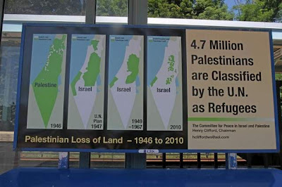 Image of “Disappearing Palestine” being Tweeted all over the place.
Anyone who deals with the Israel-Palestine conflict will probably have come across the nasty four-map series purporting to show how Israel is eliminating Palestine step by step. Recently some fellow in the NY area hired space on local billboards to expose them to commuters. I contacted him and asked if he’d be willing to listen to a critique; when he said he would I sent him the following analysis. You can see his brief response - and mine - at the end.
According to what I’ve read on Mondoweiss, you seem to be of the opinion that the series of four maps showing the disappearing Palestinian presence in what was once Mandatory Palestine are factually accurate. I suggest we take a closer look.
There are various problems with the series, the most obvious being that it compares apples with oranges and also with screwdrivers, meaning that the different maps present different data-sets. Some of the data-sets themselves are inaccurate.
Judging by the picture above, your version of the maps is even more problematic than some of the other versions which are out there. I’ll relate to your version as presented on Mondoweiss.
First, the map from 1946. Even standing alone without the series, it’s misleading in that it contains two distinct types of information. The outline is of the territory controlled by the British, commonly known as Palestine. Being a map of a political entity, however, the whole thing should be the same color, green in this case, since the entire territory was ruled by the British, the white parts and the green. If one wished to show privately owned land under the sovereignty of the British according to ethnic identity, the green would have been replaced by a hodgepodge of colors. Some of the land was owned by Jews, some by Arabs (today we would call them Palestinians), some by Arab absentee landlords of other nationalities (Lebanese, Syrians, Egyptians and so on), some by European churches – Catholic Protestant, Greek Orthodox, Russian Orthodox and others, and finally, the largest section by far would have been land registered by no-one and thus belonging to the government, i.e the British.
As far as I can see, your version has omitted the Jewish ownership of property in Jerusalem (where there was a majority of Jews), and in various pockets such as the Etzion Block, Neve Yaacov, settlements on the Dead Sea, Hebron, Safed, Naharia and its hinterland, Kfar Darom in Gaza, and so on. But the main problem with this map isn’t its omissions of Jewish property, but rather the implication that any land not owned by Jews was “Palestine”. Not true. If it’s land ownership you’re trying to depict then most of the territory was owned by the British government; if it’s political sovereignty then the entire area was British.
The second map drops the issue of land ownership, and the series never returns to it. This map is a reasonably accurate depiction of the partition plan adopted by the United Nations on November 29th 1947, with one glaring omission: the Jerusalem-Bethlehem area, which was very clearly not allocated to either side, but designated as a Corpus Separandum. I emphasize: Jerusalem and Bethlehem. So the cartographer has allocated to a notional Palestine a very important piece of territory which it never had.
Of course, this map never depicted a reality. At the time it was rejected by all the Arab states which had a vote, and also by the local Arabs themselves who did not generally call themselves Palestinians at the time, but we can agree to call them that now. I’m not going to get into the question of who foiled the UN partition plan, but I think we can agree that all sides played their roles; the Jewish Yishuv, Husseini’s Palestinian forces, Kaukji’s forces, and the Egyptian, Jordanian, Syrian, Iraqi and Lebanese forces which participated in fighting in territory which had previously been under British rule.